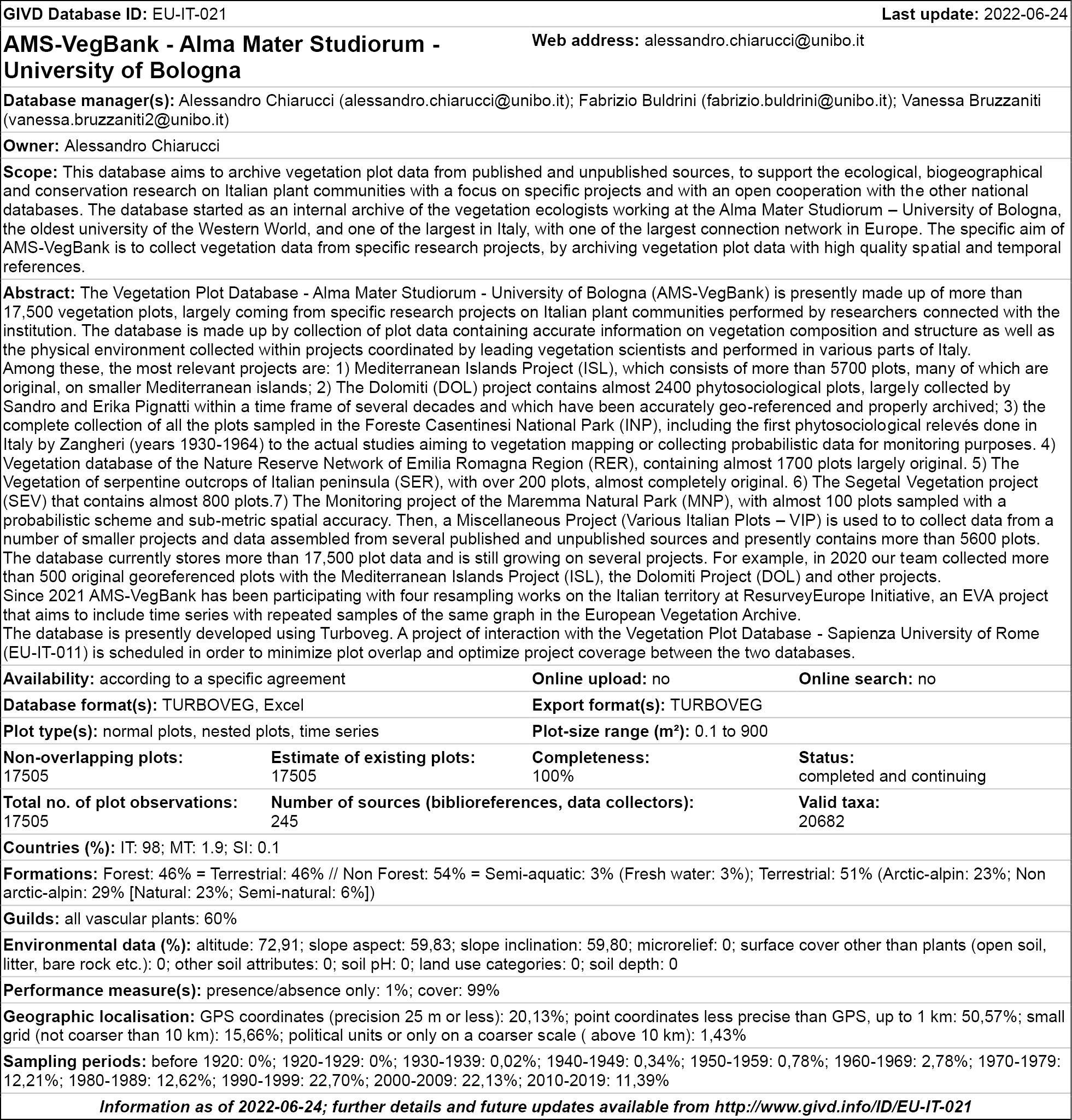
Long Database Report |
|
Corresponding author: Nicola Alessi ( nicolaalessi87@gmail.com ) Academic editor: Idoia Biurrun
© 2022 Nicola Alessi, Vanessa Bruzzaniti, Fabrizio Buldrini, Emma Centomo, Marco Cervellini, Mirko Enea, Sara Landi, Chiara Lelli, Irene Montanari, Juri Nascimbene, Giovanna Pezzi, Gianmarco Virzí, Piero Zannini, Alessandro Chiarucci.
This is an open access article distributed under the terms of the Creative Commons Attribution License (CC BY 4.0), which permits unrestricted use, distribution, and reproduction in any medium, provided the original author and source are credited.
Citation:
Alessi N, Bruzzaniti V, Buldrini F, Centomo E, Cervellini M, Enea M, Landi S, Lelli C, Montanari I, Nascimbene J, Pezzi G, Virzí G, Zannini P, Chiarucci A (2022) AMS-VegBank: a new database of vegetation plots for the Italian territory. Vegetation Classification and Survey 3: 177-185. https://doi.org/10.3897/VCS.85083
|
Abstract
The importance of collection, storage and exchange of georeferenced vegetation plot-based data has significantly grown in the recent decades, because of the new potentialities offered by ecoinformatics. In this article we introduce the Alma Mater Studiorum – University of Bologna vegetation database (AMS-VegBank; GIVD code EU-IT-021) compiling 17,505 georeferenced vegetation-plot observations within a time span of 90 years. This database includes 337,799 occurrence data of vascular plant species, belonging to many different habitat types. The historical relevance of the presented database is highlighted by the presence of some of the most ancient vegetation-plot observations in Europe (years 1930–1938). The geographic coverage of the database is mostly for Italian territory but it includes also data from other countries. The thematic focuses represented in the database are various, such as small Mediterranean islands, the Dolomite Mountains and the Italian National Parks. The large amount of historical plots available for the country not previously included in existing databases, combined with the constant action to improve the georeferencing of existing data and the addition of new data, highlight the uniqueness of this database. AMS-VegBank represents thus an important tool for studying plant biodiversity within the context of continental and global vegetation plot databases.
Taxonomic reference: All plant names reported in this article follow the nomenclature by
Abbreviations: EVA = European Vegetation Archive; GIVD = Global Index of Vegetation-Plot Databases.
Keywords
European Vegetation Archive, floristic record, Global Index of Vegetation-Plot Databases, historical plot, Italy, relevé, TURBOVEG, vegetation plot, vegetation survey
GIVD Fact Sheet
Introduction
In recent years, we have observed a constant growth of biodiversity studies and ecological informatics, thanks to the continuously growing storage and analysis capacities and the increasing relevance of biodiversity data (
The storage and reuse of these data is now a fundamental source of information to address ecological and biogeographical questions, such as vegetation and habitat classification, ecological modeling, plant species invasions, understanding biodiversity patterns from a macroecological perspective or testing island biogeography theory (
Data collection
Data collection started in early 2005 (with data stored in a local server), and was merged into a single database only in 2018. The first nucleus of the AMS-VegBank database was represented by a collection of the vegetation-plot observations performed on the small circum-Italian islands, that was then implemented by the merging of other data collections coming from projects carried out in different biogeographic regions (Alps, Apennines and Po valley). Vegetation-plot data were collected from formal publications (articles, books, monographs), but also from a large amount of «grey literature» (i.e. degree theses, doctorate theses, technical reports etc.), paying attention not to choose sources already present in other Italian databases and limit as much as possible duplications. Presently, the sources used to extract data for AMS-VegBank database are 245. Almost all the data were collected according to Braun-Blanquet’s phytosociological method, but other approaches were also considered (e.g. estimation of percentage cover for all occurring species). Data are stored in Turboveg 2.140b (
For each plot, all the site data are provided as reported in the original sources. We added new data fields to improve the administrative and geographical information of the database, namely country, region, province, municipality and macroarea (i.e. protected area, island, mountain range etc.). During the digitization process, when plots are not georeferenced (not all sources provided coordinates, namely those before the 2000s), geographical coordinates are inferred (when possible) from the name of the locality and attributed to each plot ensuring a specific dedication to convert the authors’ indications about localities in the best approximated geographic coordinates, with various degrees of accuracy estimated in meters. Accuracy is estimated based on a geographic and topographic check constantly performed, by using elevation, slope and exposition provided by the source and remote sensing information in a GIS environment. When the original sources report only the geographical coordinates, but not the accuracy, we do not estimate it. Locations of plots in the maps are always cross-checked. Presently, we are dedicating a significant effort to interact with original authors to locate coordinates and improve the quality of plot geolocalisation.
Header information provided by the original publication (e.g. locality, elevation, slope, aspect, and other environmental data) is also stored. Elevation, slope and exposition data are never corrected, even when they are potentially wrong in the original source.
The original names of the taxa recorded in each plot are always maintained, which so far generated a list of 20,682 taxa (some of them identified at the genus level, but most at the species or subspecies level), here included vascular plant species, bryophytes and lichens. Concerning vascular plant species, the nomenclature is largely based on
Database content
The AMS-VegBank is now one of the principal Italian vegetation databases in terms of data storage and geographic coverage. It presently contains 17,505 vegetation-plot data, performed in the period 1930–2021 mostly according to Braun-Blanquet’s phytosociological method (92.4%), subdivided in various thematic collections (see further). To these species co-occurrence data correspond 337,799 plant species records. These data derive from formally published papers (71.4%), BSc, MSc and PhD theses (11.9%), unpublished data from specific projects of vegetation sampling in areas of particular naturalistic relevance (14.4%), and present fieldwork performed by the members of the BIOME Lab of the University of Bologna. 5015 vegetation plots (28.6%) are still unpublished (Table
A brief description of the various collections of plot data making up the AMS-VegBank is given in the following paragraphs.

Synopsis of the vegetation plot data stored in AMS-VegBank, both published and unpublished, subdivided by thematic collections.
| Dataset | Vegetation plot data | Total | |
|---|---|---|---|
| Published | Unpublished | ||
| Small Mediterranean Islands | 4675 | 1048 | 5723 |
| Various Italian Plots | 3880 | 1736 | 5616 |
| Dolomites | 2166 | 221 | 2387 |
| Protected areas of Emilia-Romagna | 176 | 1505 | 1681 |
| Italian National Parks | 583 | 415 | 998 |
| Segetal vegetation | 779 | 779 | |
| Serpentine outcrops of the Italian peninsula | 231 | 231 | |
| Maremma Regional Park | 90 | 90 | |
| Total | 12490 | 5015 | 17505 |
Synopsis of the vegetation plot data stored in AMS-VegBank subdivided by decade. The years mentioned are referred to plot observations.
| Decade | Plot number |
|---|---|
| 1921–1930 | 1 |
| 1931–1940 | 41 |
| 1941–1950 | 25 |
| 1951–1960 | 186 |
| 1961–1970 | 578 |
| 1971–1980 | 2340 |
| 1981–1990 | 2132 |
| 1991–2000 | 5010 |
| 2001–2010 | 3388 |
| 2011–2020 | 3674 |
| 2021–2030 | 130 |
| Total number | 17505 |
Dataset «Small Mediterranean Islands»
This dataset includes 5723 vegetation plots, 1048 still unpublished (18.3% of the total), sampled over the period 1950–2021 in 54 islands and islets of the central Mediterranean area. The archipelagos with the highest concentration of plot data are, in descending order, the Tuscan Archipelago, the Maltese Islands, the Aeolian Islands, the Pelagian Islands and the Tremiti Islands. The Tuscan Archipelago counts 1616 plots (period 1975–2010), of which 331 still unpublished (20.5% of the total). The plot data derive largely from regional projects of vegetation description performed during the 1990s and 2000s, and the corpus of plots was used for testing fundamental biogeographical theories such as island species-area relationship and the importance of habitats as independent predictors of species richness patterns and species composition within islands (
The territory covered by this dataset is 968.4 km² wide and the altitudinal range varies from 0 to 1000 m a.s.l., with a clear predominance of the plots falling within the range 0–150 m. The vegetation is articulated in Mediterranean chasmophytic and xerophilous (at times halophilous) communities, typical of both calcareous and volcanic substrates, Mediterranean maquis, sometimes residual Mediterranean forests dominated by Quercus ilex or, rarely, Pinus halepensis.
The islands considered in this database have a great value from a biological and biogeographical viewpoint, also because they host various endemic species: e.g. Centaurea veneris in the Palmaria and Tinetto islands, Centaurea aetaliae, Crocus ilvensis, Limonium gorgonae, Viola corsica subsp. ilvensis in the Tuscan Archipelago, Allium diomedeum, Centaurea diomedea, Limonium diomedeum in the Tremiti Islands, Bituminaria basaltica, Dianthus rupicola subsp. aeolicus, Erysimum brulloi, Silene hicesiae in the Aeolian Islands, Cheirolophus crassifolius, Cremnophyton lanfrancoi, Helichrysum panormitanum subsp. melitense, Linaria pseudolaxiflora in the Maltese Islands etc.
Dataset «Dolomites»
This dataset contains an important collection of 2387 vegetation plots (221 still unpublished, i.e. 9.3%) collected in the period 1955–2019 in the Dolomite Mountains. The majority of these plots (1962 plots, 82.2%) were performed by Sandro Pignatti and Erika Wikus Pignatti, during several decades, and largely used to produce a monographic book (
Dataset «Italian National Parks»
This dataset includes 998 vegetation plots (period 1930–2021), 415 of which are still unpublished (41.6%). Many of them were performed in the Foreste Casentinesi National Park, one of the most important forest areas at a European level, with wide old-growth mixed forests of Fagus sylvatica and Abies alba (
This data set is now being expanded in order to cover all the national parks of Italy, to provide a useful analytical tool for assessing the biodiversity of this important network of protected areas.
Dataset «Protected Areas of Emilia-Romagna»
This dataset includes 1681 vegetation plots, 1505 of which are available at a dedicated data centre of the regional administration (
Dataset «Serpentine outcrops of the Italian peninsula»
This dataset counts 231 vegetation plots (period 1994–1998), already published, performed on mafic and ultramafic rocky substrates in Tuscany and eastern Liguria (e.g.
Dataset «Segetal vegetation»
This database counts 779 vegetation plots (period 1952–2019), already published, principally performed in northern and central Italy, in areas cultivated with cereals, maize, legumes and other vegetables. The vegetation is characterised by segetal and commensal species, weeds and species with broad ecological spectrum. Part of this group of vegetation plots was already used for a comprehensive study on the vegetation of arable habitats of central Europe (
Dataset «Maremma Regional Park»
This database counts 90 vegetation plots (period 2007–2009), all of them unpublished and deriving from a dedicated project of vegetation monitoring within the Maremma Regional Park, a coastal area of great naturalistic value, still largely undisturbed. Despite small in size, this data set is relevant for the spatial representativeness of the data and for the accuracy of geolocalisation. In fact, the plots of this project were recorded according to a probabilistic sampling design and are therefore spatially representative of the park conditions. All plots have a high accurate spatial location (< 1 m). The vegetation here represented is Mediterranean, essentially ascribable to maquis, Quercus ilex or Pinus spp. forests, garrigues, coastal or halophilous communities etc.
Dataset «Various Italian plots»
This dataset counts 5616 vegetation plots (period 1951–2021), of which 1736 still unpublished (30.9%). It is a miscellaneous collection of plots not included in the above mentioned datasets, which were performed in various environments (quarries, springs, river beds, rocky hills, forests, marine coasts etc.) and published in different contexts (technical reports, degree theses, academic studies), therefore the vegetation here represented is ascribable to many diverse physiognomic types.
Future perspectives and ongoing projects
AMS-VegBank is a large and consolidated database of vegetation-plot data, largely but not esclusively focusing on Italian area, storing a huge amount of quality data for some specific geographic areas (e.g. small Mediterranen islands, Dolomite Mountains), for some important protected areas (e.g. Italian National Parks, protected areas of Emilia-Romagna), but also includes vegetation-plot data on other thematic subjects, such as serpentine outcrops, segetal vegetation and others. This makes AMS-VegBank a multi-thematic database covering different habitats and ecosystems of the Italian country and surrouding areas.
As above indicated, data collection and storage in AMS-VegBank database is still ongoing and the number of plot data preserved in the database is continuously and quickly growing. Presently active projects include the digitization of studies carried out by the members of the research group, such as a large project performed in 2015 on the gypsum outcrops of the Emilia-Romagna region (ca. 160 plots), a project on the Apennine chestnut groves (ca. 500 plots), a project on the drainage canals of the Po valley (ca. 120 plots, that will be a precious peculiarity of AMS-VegBank: drainage canals are generally little considered by vegetation and plant ecologists, therefore vegetation data for these environments are very rare and frequently confined to the grey literature –
Substantially, AMS-VegBank is now an important reference for making available to the global scientific community the vegetation-plot data of many Italian and other Mediterranean areas.
Despite the figures here provided, the data entry to AMS-VegBank are constantly growing, because of several ongoing digitization projects. All the data provided here are updated to 24 June 2022.
Authors contributions
AC, NA, FB and VB conceptualised the paper. FB wrote a first draft, NA and AC contributed to this draft with data elaboration, figures and critical comments, VB managed the database. MC, ME, CL, IM, JN, GV, GP and PZ provided vegetation plot data and useful suggestions. All authors critically read and approved the final version of the article.
Acknowledgements
We deeply thank the Pignatti family for allowing us to digitize and store in AMS-VegBank the vegetation plot data performed on the Dolomites. We are also grateful to all the vegetation experts who sampled the collected plots. Last, but not least, we are deeply grateful to all the students that helped us to digitize the vegetation relevés present in the database: Ahmed Mohamed Mahmoud Mohamed Abouyoussef, Francesca Agosteo, Luis Cáceres Polgrossi, Pietro Caldart, Luca Frattini, Nicolò Garbo, Komal Iftikhar, Kamal Kamalzade, Ikram Khaled, Alessia Matteotti, Martina Neri, Martina Pelliconi, Angela Peruzzi, Federica Pirazzini, Masood Roohi, Giacomo Rossetti, Elena Rossi, Vito Sasso, Ahmad Shaoor, Li Shi, Stefania Telaro, Agnese Tonini, Silvia Volpe. Nicola Alessi and Piero Zannini have been supported by LifeWatch Italy through the project LifeWatchPLUS (CIR-01_00028).
References
- Biurrun I, Pielech R, Dembicz I, Gillet F, Kozub Ł, Marcenò C, Reitalu T, Van Meerbeek K, Guarino R, … Dengler J (2021) Benchmarking plant diversity of Palaearctic grasslands and other open habitats. Journal of Vegetation Science 32: e13050. https://doi.org/10.1111/jvs.13050
- Blasi C, Burrascano S, Maturani A, Sabatini FM (2010) Contributo tematico alla Strategia Nazionale per la Biodiversità. Foreste Vetuste in Italia [A thematic contribution to the National Strategy for Biodiversity. The old–growth forests in Italy]. Ministero dell’Ambiente e della Tutela del Territorio e del Mare, Roma, IT.
- Bruelheide H, Dengler J, Jiménez‐Alfaro B, Purschke O, Hennekens SM, Chytrý M, Pillar VD, Jansen F, Kattge J, … Zverev A (2019) sPlot – A new tool for global vegetation analyses. Journal of Vegetation Science 30: 161–186. https://doi.org/10.1111/jvs.12710
- Brullo S, Brullo C, Cambria S, Giusso del Galdo G (2020) The vegetation of the Maltese Islands. Springer Nature, Cham, CH. https://doi.org/10.1007/978-3-030-34525-9
- Chiarucci A (2003) Vegetation ecology and conservation on Tuscan ultramafic soils. The Botanical Review 69: 252–268. https://doi.org/10.1663/0006-8101(2003)069[0252:VEACOT]2.0.CO;2
- Chiarucci A, Bacaro G, Filibeck G, Landi S, Maccherini S, Scoppola A (2012) Scale dependence of plant species richness in a network of protected areas. Biodiversity and Conservation 21: 503–516. https://doi.org/10.1007/s10531-011-0196-8
- Chiarucci A, Buldrini F, Cervellini M, Guarino R, Caccianiga M, Foggi B, Viciani D, Lazzaro L, Casella L, … Zannini P (2021) Habitat type and island identity as drivers of community assembly in an archipelago. Journal of Vegetation Science 32: e12953. https://doi.org/10.1111/jvs.12953
- Chiarucci A, Robinson BH, Bonini I, Petit D, Brooks RR, De Dominicis V (1998) Vegetation of tuscan ultramafic soils in relation to edaphic and physical factors. Folia Geobotanica 33: 113–131. https://doi.org/10.1007/BF02913340
- Chytrý M, Rafajová M (2003) Czech National Phytosociological Database: basic statistics of the available vegetation-plot data. Preslia 75: 1–15.
- Chytrý M, Hennekens SM, Jiménez-Alfaro B, Knollová I, Dengler J, Jansen F, Landucci F, Schaminée JHJ, Aćić S, … Yamalov S (2016) European Vegetation Archive (EVA): an integrated database of European vegetation plots. Applied Vegetation Science 19: 173–180. https://doi.org/10.1111/avsc.12191
- Chytrý M, Tichý L, Hennekens SM, Knollová I, Janssen JA, Rodwell JS, Peterka T, Marcenò C, Landucci F, … Schaminée JH (2020) EUNIS Habitat Classification: Expert system, characteristic species combinations and distribution maps of European habitats. Applied Vegetation Science 23: 648–675. https://doi.org/10.1111/avsc.12519
- Conti F, Abbate G, Alessandrini A, Blasi C (2005) An annotated checklist of the Italian vascular flora. Palombi Editori, Roma, IT.
- Conti F, Alessandrini A, Bacchetta G, Banfi E, Barberis G, Bartolucci F, Bernardo L, Bonacquisti S, Bouvet D, … Vidali M (2007) Integrazioni alla Checklist della flora vascolare italiana [Integrations to the Checklist of the Italian vascular flora]. Natura Vicentina 10: 5–74.
- Dengler J, Jansen F, Glöckler F, Peet RK, De Cáceres M, Chytrý M, Ewald J, Oldeland J, Finckh M, … Spencer N (2011) The Global Index of Vegetation-Plot Databases (GIVD): a new resource for vegetation science. Journal of Vegetation Science 22: 582–597. https://doi.org/10.1111/j.1654-1103.2011.01265.x
- Dengler J, Wagner V, Dembicz I, García-Mijangos I, Naqinezhad A, Boch S, Chiarucci A, Conradi T, Filibeck G, … Biurrun I (2018) GrassPlot – a database of multi-scale plant diversity in Palaearctic grasslands. Phytocoenologia 48: 331–347. https://doi.org/10.1127/phyto/2018/0267
- Ferrari C (1980) Flora e vegetazione dell’Emilia-Romagna [Flora and vegetation of the Emilia-Romagna]. Regione Emilia-Romagna, Bologna, IT.
- Fiori A (1923–1929) Nuova Flora Analitica d’Italia [New analytical Flora of Italy]. Tipografia di M. Ricci, Firenze, IT.
- Font X, Pérez-García N, Biurrun I, Fernández-González F, Lence C (2012) The Iberian and Macaronesian Vegetation Information System (SIVIM, www.sivim.info), five years of online vegetation’s data publishing. Plant Sociology 49(1): 89–95.
- Franklin J, Serra-Diaz JM, Syphard AD, Regan HM (2017) Big data for forecasting the impacts of global change on plant communities. Global Ecology and Biogeography 26: 6–17. https://doi.org/10.1111/geb.12501
- Glaser M, Berg C, Buldrini F, Buholzer S, Bürger J, Chiarucci A, Chytrý M, Dřevojan P, Follak S, … Essl F (2022) AgriWeedClim Database: A Repository of Vegetation Plot Data from Central European Arable Habitats over 100 Years. Applied Vegetation Science 25: e12675. https://doi.org/10.1111/avsc.12675
- Hennekens SM, Schaminée JHJ (2001) TURBOVEG, a comprehensive data base management system for vegetation data. Journal of Vegetation Science 12: 589–591. https://doi.org/10.2307/3237010
- Lelli C, Nascimbene J, Chiarucci A (2018) Are available vegetation data suitable for assessing plant diversity? A study case in the Foreste Casentinesi National Park (Italy). Rendiconti Lincei. Scienze Fisiche e Naturali 29(2): 355–362. https://doi.org/10.1007/s12210-018-0681-z
- Lelli C, Nascimbene J, Alberti D, Agostini N, Zoccola A, Piovesan G, Chiarucci A (2021) Long‐term changes in Italian mountain forests detected by resurvey of historical vegetation data. Journal of Vegetation Science 32: e12939. https://doi.org/10.1111/jvs.12939
- Montanari I, Buldrini F, Bolpagni R, Laini A, Dalla Vecchia A, De Bernardini N, Campione L, Castellari I, Gizzi G, … Chiarucci A (2020) Role of irrigation canal morphology in driving riparian flora in over-exploited catchments. Community Ecology 21: 121–132. https://doi.org/10.1007/s42974-020-00024-5
- Pignatti E, Pignatti S (2014) Plant Life of the Dolomites. Springer, Berlin-Heidelberg, DE. https://doi.org/10.1007/978-3-642-31043-0
- Pignatti S, Guarino R, La Rosa M (2017–2019) Flora d’Italia, II ed. [Flora of Italy, 2nd ed.]. Edagricole, Bologna, IT.
- Regione Emilia-Romagna (2022) Geoportale. [URL:] https://geoportale.regione.emilia-romagna.it/ [Accessed 20 Feb 2022]
- Sabatini FM, Lenoir J, Hattab T, Arnst EA, Chytrý M, Dengler J, De Ruffray P, Hennekens SM, Jandt U, … Kattge J (2021) sPlotOpen – An environmentally balanced, open-access, global dataset of vegetation plots. Global Ecology and Biogeography 30: 1740–1764. https://doi.org/10.1111/geb.13346
- Schaminée JHJ, Hennekens SM, Chytrý M, Rodwell JS (2009) Vegetation-plot data and databases in Europe: an overview. Preslia 81: 173–185.
- Schaminée JHJ, Hennekens SM, Ozinga WA (2012) The Dutch National Vegetation Database. Biodiversity and Ecology 4: 201–209. https://doi.org/10.7809/b-e.00077
- Viciani D, Gonnelli V, Sirotti M, Agostini N (2010) An annotated check-list of the vascular flora of the “Parco Nazionale delle Foreste Casentinesi, Monte Falterona e Campigna” (Northern Apennines Central Italy). Webbia 65: 3–131. https://doi.org/10.1080/00837792.2010.10670867
- Wagner V, Večeřa M, Jiménez‐Alfaro B, Pergl J, Lenoir J, Svenning JC, Pyšek P, Agrillo E, Biurrun I, … Chytrý M (2021) Alien plant invasion hotspots and invasion debt in European woodlands. Journal of Vegetation Science 32: e13014. https://doi.org/10.1111/jvs.13014
- Zangheri P (1966) Flora e Vegetazione del medio e alto Appennino Romagnolo [Flora and vegetation of the middle and high Apennines of Romagna]. Webbia 21: 1–451. https://doi.org/10.1080/00837792.1966.10669838
- Zangheri P (1976) Flora Italica [Flora of Italy]. CEDAM, Padova, IT.
E-mail and ORCID
- Nicola Alessi (Corresponding author, nicola.alessi5@unibo.it), ORCID: https://orcid.org/0000-0002-4479-950X
- Vanessa Bruzzaniti (vanessa.bruzzaniti2@unibo.it)
- Fabrizio Buldrini (fabrizio.buldrini@unibo.it), ORCID: http://orcid.org/0000-0002-0376-6760
- Emma Centomo (emma.centomo@studio.unibo.it)
- Marco Cervellini (marco.cervellini5@unibo.it), ORCID: https://orcid.org/0000-0002-0853-2330
- Mirko Enea (mirko.enea@studio.unibo.it)
- Sara Landi (landi@greenarco.com), ORCID: https://orcid.org/0000-0002-6795-2132
- Chiara Lelli (chiara.lelli7@unibo.it), ORCID: http://orcid.org/0000-0002-0497-828X
- Irene Montanari (irene.montanari8@unibo.it)
- Juri Nascimbene (juri.nascimbene@unibo.it), ORCID: https://orcid.org/0000-0002-9174-654X
- Giovanna Pezzi (giovanna.pezzi@unibo.it), ORCID: http://orcid.org/0000-0001-9739-3530
- Gianmarco Virzí (gianmarco.virzi@studio.unibo.it), ORCID: https://orcid.org/0000-0003-0149-5642
- Piero Zannini (piero.zannini2@unibo.it), ORCID: http://orcid.org/0000-0003-2466-4402
- Alessandro Chiarucci (alessandro.chiarucci@unibo.it), ORCID: http://orcid.org/0000-0003-1160-235X